GEE RADAR
This was designed by R.J.Dippy, his original proposal was put foward when he worked at Bawdsey Manor, Suffolk.
In late 1940 he was posted to Worth Matravers where he developed GEE RADAR navigation using a local GEE Arial based at Worth Matravers.
GEE RADAR Navigation
In the third week of June 1940 the British discovered that the Germans had a radio navigation system that allowed the Luftwaffe’s night bombers to locate selected targets over England, named Knikebeine. This prompted scientists in England to design their own system, but unlike the German continuous wave the British version would be pulsed, because this was not as easy to jam.
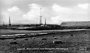
This was designed by R.J.Dippy, his original proposal was put foward when he worked at Bawdsey Manor, in late 1940 he was posted to Worth Matravers where he developed GEE RADAR navigation using a local GEE Arial and station based at Worth. In 1941, he moved to Durnford House, a requisitioned Prep school, by March 1942 GEE was in service. After the war the aerial mast had a red air navigation light installed at the top that was visible from the A351 between Corfe Castle and Harmans Cross, this arial remained at Worth until 1971 and was the last one to be removed.
Dippy’s design utilised the synchronizied pulses from three widlely spaced transmitters. A receiver on an aircraft received signals from three transmitters, situated on the ground. One acted as a master station that triggered the other two to transmit on alternate pulses from the master, these were known as slave stations. The transmitted pulses were displayed on a cathode ray tube with a double time base. The distance of the aircraft from each slave station could be measured on a scale. These distances would be compared to grids on the navigators maps and the location determined by the point where the lines crossed. This enabled the aircraft navigator in any number of aircraft to simultaneously pinpoint their position using a combination of the time measurements and a specially prepared chart.
The first version Mk1 encountered serious jamming whilst on a bombing raid over Essen on the night of August 4/5, 1942. It was so severe that sets lost their signals 10-20 miles short of the target. The range of effective GEE reception was cut by half. The issue was resolved later and on December 3/4, 1942, useful fixes were taken whilst bombing Turin, Italy, at a range of 730 miles; the longest range on record 44.
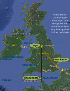
From the image, the black line running from the Cap de la Hague to Manchester, the bombing target, represents the primary beam, the night bombers would follow this beam north, over Swanage and Poole using their Port and Starboard Aerials to align the aircraft to the beam of radar pulses transmitted from Cap de la Hague. When the aircraft received the beam from Calais, orange line, this would warn the Navigator/Bomb Aimer that they were 20 kilometres from Manchester, the target. When they received the second beam they were 5 kilometres from target, just short of their bomb release position.
Telecommunications Research Establishment (TRE) RAF Worth Matravers was the first organisation to discover that the Germans were using Beam Radar. They detected it whilst monitoring German radar beams emitted from a gun battery located at Calais, the radar beam was used to determine the gun trajectory when bombarding convoy ships in the English Channel.
In November 1940 TRE had developed a system to disrupt the aircraft navigation beams, but it was not successful. They required an aircraft that had a Radar Beam detector, known as X-Gerat equipment, to check their theory. Their wish was granted on the 6 November when a home bound German Bomber suffered a compass malfunction and crashed landed on a Dorset beach near Bridport.
After TRE collected the X-Grerat they modified their design so that it became possible to redirect the German aircraft away from their target and onto agricultural land. This was not soon enough to save Coventry from destruction on the 14 November. In this attack the German secondary radar beam transmitter was located at Cleves, Belgium as opposed to Calais. 3
GEE RADAR Navigation
During March and April 1942 Bomber Command, led by Arthur Harris, made eight attacks against Esson, Germany, all with relatively poor results. Two hundred and 12 photos were taken by 1000 bombers, but only 22 could be plotted within five miles of the city. A variety of issues were reported, the most serious and frequent, a failure of the Flare droppers to use GEE to determine their release point. The photos were examined and in the worst case scenario when the target was subject to poor visibility due to thick haze or excessive cloud, the success rate fell to 10% correlation between presumed and photographic position. Subsequent investigation revealed that most of the flares illuminating the target had been dropped into the correct location, the majority of the main bomber force arrived after the flares had gone out and the bombers dropped their incendiary bombs over a wide area. Even worst, the more tardy bombers were fooled by the previous bombers and dropped their bombs in a wider area from the true target.
Harris stated that GEE was not a blind bombing device, but a good device for getting the bomber into the vicinity of the target and from where visual identification could be made. Overall, he concluded, to improve GEE’s effectiveness two things should support it. The use of a Marker Bomb or target indicator TI and a new member of the air crew, somebody who would act as bomb aimer, whose function would not be added to those of the navigator, but would be a specialist, specifically trained in sight and bomb aiming 42.
Gee Limitations
Gee was a navigational advance but it had three weaknesses: its range was limited to Line-of Site transmissions; its accuracy was of the order of Kilometres and jamming.
This was expected from the start, the first instance was on 4th Aug 1942 when German Heinrich RADAR jammers successfully blocked the GEE frequency. This prompted TRE to develop alternative navigational aids. Two of the most important was Oboe and H2S, both introduced in December 1942. Gee remained in service, as it was not always jammed and was excellent for pilot navigation, the Luftwaffe used it when entering England. This was reciprocated when the Luftwaffe introduced Elektra Sonne and set up a station in neutral Spain and a second at Brest. it enabled the RAF to navigate over the Bay of Biscay using the German Navigation Beams 37 .

